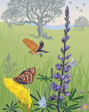
Grassland
Native grasslands (upland and wetland) were once a dominant habitat type in the Valley. Today less than one
percent remains making it one of the most critically endangered ecosystems of the United States. Because so
little remains, we used unmanaged pasture, grasslands within protected areas, and pasture/hay landcover types to
represent grasslands, but only if they occurred in areas mapped as prairie on the 1951 historical vegetation map
of the Willamette Valley.
Grassland within 2km of Western Meadowlark
Because one of our goals is to recover grassland birds as represented by western meadowlark and Oregon vesper
sparrow and we want to work where we know these birds are located, we highlighted areas within 2 kilometers of a
recent documented occurrences of either species.
Grassland within 2km of Oregon Vesper Sparrow
Because one of our goals is to recover grassland birds as represented by western meadowlark and Oregon
vesper sparrow and we want to work where we know these birds are located, we highlighted areas within
2 kilometers of a recent documented occurrences of either species.
Oak Savanna
Oak savanna is a component of grasslands, characterized by widely spaced oak trees in a grassland setting.
Similar to native grasslands, less than one percent of this habitat remains. In the absence of disturbances such
as fire, conifers invade and many historic savannas have converted to forest.
Oak savanna within 2km of Western Bluebird
Because one of our goals is to recover savanna species as represented by western bluebirds, we highlighted areas
within 2 kilometers of recent documented occurrences of western bluebirds.
Oak Woodland
Oak woodlands generally occur along the transition between grasslands of the valley floor and higher elevation
conifer-dominated forests (Christy and Alverson 2011). Similar to savannas, in the absence of disturbances such
as fire, conifers invade and convert oak woodlands to mixed forest types. Because most oak woodlands have been
invaded by conifers, we had to include areas dominated by other types of trees but include retain a sizable
minority of oak trees. Actions will be needed to restore these areas to oak woodlands.
Oak Woodland within 2km of White-breasted Nuthatch
Because one of our goals is to recover oak woodland species as represented by the slender-billed white-breasted
nuthatch, we highlighted areas within 2 kilometers of recent documented occurrences of white-breasted nuthatch.
Riparian Areas
Riparian areas are known by many names: bottomland hardwood forests, gallery forests, wetland or riparian
forests, riparian shrublands, and willow shrublands. They are most prominent along low-elevation floodplains and
lower river terraces. Like other native habitats of the valley, there has been a significant loss of these
habitats.
Riparian forest within 2km of Yellow Warbler
We split riparian areas into two component parts: forests and shrublands, and selected yellow warbler
and yellow breasted-chat to represent them. We highlighted riparian areas within 2 kilometers of recent
documented occurrences of either species.
Riparian shrubland within 2km of Yellow Breasted Chat
We split riparian areas into two component parts: forests and shrublands, and selected yellow warbler and yellow
breasted-chat to represent them. We highlighted riparian areas within 2 kilometers of recent documented
occurrences of either species.
Riparian wetlands of conservation of concern
There is a high degree of overlap between mapped riparian areas and other important habitat elements which have
been mapped by others. These include: Wetlands of Conservation Concern as mapped by The Wetlands Conservancy for
the Western Governors Association’s Crucial Habitat Assessment Tool or CHAT (WGWC 2013);
Riparian anchor habitat
There is a high degree of overlap between mapped riparian areas and other important habitat elements which have
been mapped by others. These include: Anchor Habitats – areas with opportunities to reconnect the river to its
historic floodplain with limited social impact that were mapped as part of the Willamette Planning Atlas (Hulse
et al. 2002) and by the Oregon Watershed Enhancement Board (OWEB 2014)
Riparian cold points
There is a high degree of overlap between mapped riparian areas and other important habitat elements which have
been mapped by others. These include: critically important instream cold water refugia (cold points) as mapped
by Hulse et al. (2007)
Riparian zones of influence
There is a high degree of overlap between mapped riparian areas and other important habitat elements which have
been mapped by others. These include: Zone of Influence – locations of revetments that if removed would provide
a high degree of fish habitat restoration with limited social impacts that were mapped as part of a US Army
Corps of Engineers’ study (Hulse et al. 2013).